SurfaceManager
Description
The SurfaceManager object lists the surfaces in a radar scenario,
radarScenario. You
can enable or disable occlusion and multipath interactions from surfaces in the radar
scenario. The occlusion object
function determines if any surfaces occlude the line-of-sight between two points. Use the
height object
function to query the height of surfaces at any location in the scenario.
Creation
Use the landSurface object
function to create LandSurface objects.
Use the seaSurface object
function to create SeaSurface objects.
Use the customSurface
object function to create CustomSurface
objects. Obtain the SurfaceManager object from the
SurfaceManager property of the radarScenario
object.
Properties
Object Functions
height | Height of point on surface |
occlusion | Test for occlusion of point by a surface |
surfacePlotterData | Data for surface plotter |
Examples
Create a radar scenario and specify its IsEarthCentered property as true to use DTED file.
scene = radarScenario(IsEarthCentered = true);
Model the reflectivity as a constant gamma surface.
refl = surfaceReflectivityLand(Model = 'ConstantGamma',Gamma = -20);Add a 0.1-by-0.1 degree land surface derived from a DTED file.
bdry = [39.5 39.6;-105.51 -105.41];
srf = landSurface(scene,Terrain = 'n39_w106_3arc_v2.dt1', ...
    Boundary = bdry,RadarReflectivity = refl)
srf =
  LandSurface with properties:

        RadarReflectivity: [1×1 surfaceReflectivityLand]
    ReflectionCoefficient: [1×1 radar.scenario.SurfaceReflectionCoefficient]
          ReflectivityMap: 1
          ReferenceHeight: 0
                 Boundary: [2×2 double]
                  Terrain: 'n39_w106_3arc_v2.dt1'
mgr = scene.SurfaceManager
mgr =
  SurfaceManager with properties:

    EnableMultipath: 0
       UseOcclusion: 1
           Surfaces: [1×1 radar.scenario.LandSurface]
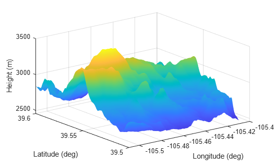
Plot the surface height.
x = linspace(srf.Boundary(2,1),srf.Boundary(2,2),201);
y = linspace(srf.Boundary(1,1),srf.Boundary(1,2),201);
[X,Y] = meshgrid(x,y);
X1 = X(:)';
Y1 = Y(:)';
H = height(srf,[Y1;X1]);
H = reshape(H,length(x),length(y));
surf(x,y,H)
shading interp
ylabel('Latitude (deg)')
xlabel('Longitude (deg)')
zlabel('Height (m)')
Version History
Introduced in R2022a