maptrimp
Trim polygons to latitude-longitude quadrangle
Syntax
[latTrimmed,lonTrimmed] = maptrimp(lat,lon,latlim,lonlim)
Description
[latTrimmed,lonTrimmed] = maptrimp(lat,lon,latlim,lonlim) trims
the polygons in lat and lon to
the quadrangle specified by latlim and lonlim.
latlim and lonlim are two-element
vectors, defining the latitude and longitude limits respectively. lat and lon must
be vectors that represent valid polygons.
Examples
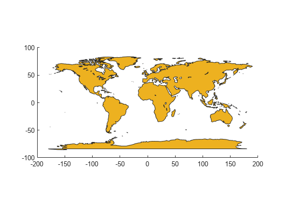
Read coastline data and display it on a map.
load coastlines
figure
mapshow(coastlon,coastlat,'DisplayType','polygon');
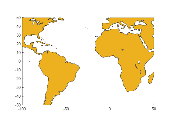
Trim the dataset.
latlim = [-50 50];
lonlim = [-100 50];
[latTrimmed,lonTrimmed] = maptrimp(coastlat,coastlon, ...
   latlim, lonlim);
Display the trimmed dataset.
figure
mapshow(lonTrimmed,latTrimmed, 'DisplayType', 'polygon');
Tips
maptrimp conditions the longitude limits
such that:
lonlim(2)always exceedslonlim(1)lonlim(2)never exceedslonlim(1)by more than360lonlim(1) < 180orlonlim(2) > -180Ensure that if the quadrangle span the Greenwich meridian, then that meridian appears at longitude
0.
Version History
Introduced before R2006a