Main Content

cart2sph

Transform Cartesian coordinates to spherical

Description

example

[azimuth,elevation,r] = cart2sph(x,y,z) transforms corresponding elements of the Cartesian coordinate arrays x, y, and z to spherical coordinates azimuth, elevation, and r.

Examples

collapse all

Convert the Cartesian coordinates defined by corresponding entries in the matrices x, y, and z to spherical coordinates az, el, and r. These points correspond to the eight vertices of a cube.

x = [1 1 1 1; -1 -1 -1 -1]
x = 2×4

     1     1     1     1
    -1    -1    -1    -1

y = [1 1 -1 -1; 1 1 -1 -1]
y = 2×4

     1     1    -1    -1
     1     1    -1    -1

z = [1 -1 1 -1; 1 -1 1 -1]
z = 2×4

     1    -1     1    -1
     1    -1     1    -1

[az,el,r] = cart2sph(x,y,z)
az = 2×4

    0.7854    0.7854   -0.7854   -0.7854
    2.3562    2.3562   -2.3562   -2.3562

el = 2×4

    0.6155   -0.6155    0.6155   -0.6155
    0.6155   -0.6155    0.6155   -0.6155

r = 2×4

    1.7321    1.7321    1.7321    1.7321
    1.7321    1.7321    1.7321    1.7321

Input Arguments

collapse all

Cartesian coordinates, specified as scalars, vectors, matrices, or multidimensional arrays. x, y, and z must be the same size, or have sizes that are compatible (for example, x is an M-by-N matrix, y is a scalar, and z is a scalar or 1-by-N row vector). For more information, see Compatible Array Sizes for Basic Operations.

Data Types: single | double

Output Arguments

collapse all

Azimuth angle, returned as an array. azimuth is the counterclockwise angle in the x-y plane measured in radians from the positive x-axis. The value of the angle is in the range [-pi pi].

Elevation angle, returned as an array. elevation is the elevation angle in radians from the x-y plane. The value of the angle is in the range [-pi/2, pi/2].

Radius, returned as an array. r is the distance from the origin to a point. The length units of r are arbitrary, matching the units of the input arrays x, y, and z.

Algorithms

The mapping from three-dimensional Cartesian coordinates to spherical coordinates is

azimuth = atan2(y,x)
elevation = atan2(z,sqrt(x.^2 + y.^2))
r = sqrt(x.^2 + y.^2 + z.^2)

Figure shows a point plotted in 3-D space with X and Y in the horizontal plane and Z along the vertical axis. The point has a radius measured from the origin, an azimuthal angle measured in relation to X in the horizontal plane, and an elevation angle measured as elevation above the XY plane.

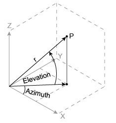
The notation for spherical coordinates is not standard. For the cart2sph function, elevation is measured from the x-y plane. Notice that if elevation = 0, the point is in the x-y plane. If elevation = pi/2, then the point is on the positive z-axis.

Extended Capabilities

C/C++ Code Generation
Generate C and C++ code using MATLAB® Coder™.

Version History

Introduced before R2006a