Satellite
R2026bSatellite in satellite scenario
Description
Satellite defines a satellite in satellite scenario object.
Creation
You can create Satellite objects using the satellite function of satelliteScenario
object.
Properties
You can set this property only when calling the satellite function. After you call satellite function, this property is read-only.
Satellite name, specified as a name-value argument consisting of 'Name' and a string scalar, string vector, character vector or a cell array of character vectors.
If only one satellite is added, specify
Nameas a string scalar or a character vector.If multiple satellites are added, specify
Nameas a string scalar, character vector, string vector or a cell array of character vectors. All satellites added as a string scalar or a character vector are assigned the same specified name. The number of elements in the string vector or cell array of character vector must equal the number of satellites being added. Each satellite is assigned the corresponding name from the vector or cell array.
The default value when satellite is added to the satellite scenario using
Keplerian orbital elements, TLE file — "Satellite ID", where
IDis assigned by the satellite scenario.SEM almanac file or RINEX GPS navigation data — "PRN:prnValue", where prnValue is an integer denoting the pseudorandom noise code of the satellite as specified in the SEM almanac file.
RINEX Galileo navigation data — "GAL Sat IF: id", where "id" is the satellite ID of the Galileo satellite defined in the RINEX navigation data.
Timetable - Variable names of the timetable object.
Timeseries - Name of the timeseries object if populated, otherwise "Satellite ID", where ID is assigned by satellite scenario.
Data Types: string
Since R2026b
Celestial body relative to which the Keplerian element inputs (semimajorAxis, eccentricity, inclination, RAAN, argofperiapsis, and trueanomaly) or ephemeris data inputs (timetable or timeseries) are defined, specified as "Earth" or "Moon".
You can specify "Moon" only when using Keplerian element inputs or ephemeris data inputs. When CentralBody equals "Moon", TLE, OMM, SEM almanac, and RINEX data inputs are not supported and result in an error.
Note
Modification of this property requires an Aerospace Toolbox license. The following lunar operations check out this license: specifying
CentralBody="Moon" in satellite,
groundStation, or platform; specifying
ReferenceCelestialBody="Moon"; specifying
ObstructingBodies="Moon"; setting
PlanetaryEphemerisModel on a satelliteScenario;
and specifying CentralBody="Moon" in
centralBodyOptions.
Dependencies
When
CentralBodyequals"Moon"and you explicitly specify theOrbitPropagatorname-value argument, it must equal"two-body-keplerian"or"numerical". When using timetable or timeseries inputs, the propagator is set to"ephemeris"automatically.When
CoordinateFrameequals"ecef"or"geographic", theCentralBodyis assumed to be"Earth"and this input is ignored.
Data Types: string
This property is set internally by the simulator and is read-only.
Satellite ID assigned by the simulator, specified as a positive scalar.
You can set this property only when calling
the conicalSensor. After you
call the conicalSensor function, this property is read-only.
Conical sensors attached to the Satellite, specified as a row vector of conical sensors.
This property is read-only.
You can set this property only when calling transmitter function. After you call the
transmitter function, this property is read-only.
Transmitters attached to the Satellite, specified as a row vector of Transmitter
objects.
You can set this property only when calling access.
After you call access, this property is
read-only.
Access analysis objects, specified as a row vector of
Access objects.
You can set this property only when calling groundTrack. After you
call groundTrack, this
property is read-only.
Ground track of the Satellite, specified as a row vector of GroundTrack
objects.
You can set this property only when calling coordinateAxes.
After you call coordinateAxes,
this property is read-only.
Coordinate axes triad graphic object, specified as CoordinateAxes
object.
You can set this property when you create a satellite object, and
then this property becomes read-only.
Name of the orbit propagator used for propagating the satellite position and velocity, specified as one of these values:
If you specify the satellite using timetable, table,
timeseries, ortscollection, theOrbitPropagatorvalue is"ephemeris".If you specify the satellite using a SEM almanac file or RINEX data containing a GPS navigation message, the
OrbitPropagatorvalue can be one of these values:"gps"(default)"sgp4""sdp4""two-body-keplerian""numerical"
If you specify the satellite using the RINEX data containing a Galileo navigation message, the
OrbitPropagatorvalue can be one of these values:"galileo"(default)"sgp4""sdp4""two-body-keplerian""numerical"
If you specify the satellite using Keplerian elements,
OrbitPropagatorvalue can be one of these values:"two-body-keplerian""sgp4""sdp4""numerical"
Additionally, if semimajor axis is negative,
OrbitPropagatorvalue can only be"numerical". If semimajor axis is positive, default value is"sgp4"for periods less than 225 min and"sdp4"for periods greater than or equal to 225 minutes.If you specify the satellite using a TLE or OMM file, the
OrbitPropagatorvalue can be one of these values:"two-body-keplerian""sgp4""sdp4""numerical"
If the orbital period is less than 225 minutes, the default
OrbitPropagatorvalue is"sgp4". Otherwise, the defaultOrbitPropagatorvalue is"sdp4".If you specify the satellite using
Keplerianelements, theOrbitPropagatorvalue can be one of these values:"two-body-keplerian""sgp4""sdp4"
If the RINEX data contains both valid GPS and Galileo navigation messages, you cannot
specify OrbitPropagator as "gps" or
"galileo" using a name-value argument. However, you can still specify it
as "two-body-keplerian", "sgp4",
"sdp4", or "numerical".
Dependencies
When CentralBody equals "Moon" and you
explicitly specify the OrbitPropagator name-value argument, only
"two-body-keplerian" and "numerical" are valid. Setting
OrbitPropagator to "sgp4",
"sdp4", "gps", or "galileo" when
CentralBody equals "Moon" returns an error. When
using timetable or timeseries inputs, the propagator is set to
"ephemeris" automatically.
Color of the marker, specified as either an RGB triplet or a string or character vector of a color name.
For a custom color, specify an RGB triplet or a hexadecimal color code.
An RGB triplet is a three-element row vector whose elements specify the intensities of the red, green, and blue components of the color. The intensities must be in the range
[0,1], for example,[0.4 0.6 0.7].A hexadecimal color code is a string scalar or character vector that starts with a hash symbol (
#) followed by three or six hexadecimal digits, which can range from0toF. The values are not case sensitive. Therefore, the color codes"#FF8800","#ff8800","#F80", and"#f80"are equivalent.
Alternatively, you can specify some common colors by name. This table lists the named color options, the equivalent RGB triplets, and the hexadecimal color codes.
| Color Name | Short Name | RGB Triplet | Hexadecimal Color Code | Appearance |
|---|---|---|---|---|
"red"
|
"r"
|
[1 0 0]
|
"#FF0000"
|
|
"green"
|
"g"
|
[0 1 0]
|
"#00FF00"
|
|
"blue"
|
"b"
|
[0 0 1]
|
"#0000FF"
|
|
"cyan"
|
"c"
|
[0 1 1]
|
"#00FFFF"
|
|
"magenta"
|
"m"
|
[1 0 1]
|
"#FF00FF"
|
|
"yellow"
|
"y"
|
[1 1 0]
|
"#FFFF00"
|
|
"black"
|
"k"
|
[0 0 0]
|
"#000000"
|
|
"white"
|
"w"
|
[1 1 1]
|
"#FFFFFF"
|
|


Here are the RGB triplets and hexadecimal color codes for the default colors MATLAB® uses in many types of plots.
| RGB Triplet | Hexadecimal Color Code | Appearance |
|---|---|---|
[0 0.4470 0.7410]
|
"#0072BD"
|
|
[0.8500 0.3250 0.0980]
|
"#D95319"
|
|
[0.9290 0.6940 0.1250]
|
"#EDB120"
|
|
[0.4940 0.1840 0.5560]
|
"#7E2F8E"
|
|
[0.4660 0.6740 0.1880]
|
"#77AC30"
|
|
[0.3010 0.7450 0.9330]
|
"#4DBEEE"
|
|
[0.6350 0.0780 0.1840]
|
"#A2142F"
|
|
![Sample of RGB triplet [0 0.4470 0.7410], which appears as dark blue](colororder1.png)
![Sample of RGB triplet [0.8500 0.3250 0.0980], which appears as dark orange](colororder2.png)
![Sample of RGB triplet [0.9290 0.6940 0.1250], which appears as dark yellow](colororder3.png)
![Sample of RGB triplet [0.4940 0.1840 0.5560], which appears as dark purple](colororder4.png)
![Sample of RGB triplet [0.4660 0.6740 0.1880], which appears as medium green](colororder5.png)
![Sample of RGB triplet [0.3010 0.7450 0.9330], which appears as light blue](colororder6.png)
![Sample of RGB triplet [0.6350 0.0780 0.1840], which appears as dark red](colororder7.png)
Dependencies
On Aero.satellitescenario.CentralBodyOptions (Aerospace Toolbox) objects,
this property is applicable only when the
CentralBody property equals
"Moon". Otherwise, this property is
hidden and ignored.
Size of the marker, specified as a real positive scalar less than 30. The unit is in pixels.
Dependencies
On Aero.satellitescenario.CentralBodyOptions (Aerospace Toolbox) objects,
this property is applicable only when the
CentralBody property equals
"Moon". Otherwise, this property is
hidden and ignored.
State of Satellite label visibility, specified as a
name-value argument consisting of
'ShowLabel' and numerical or
logical value of 1
(true) or 0
(false).
Dependencies
On Aero.satellitescenario.CentralBodyOptions (Aerospace Toolbox) objects,
this property is applicable only when the
CentralBody property equals
"Moon". Otherwise, this property is
hidden and ignored.
Data Types: logical
Font color of the Satellite label, specified as a name-value argument consisting of
'LabelFontColor' and either an RGB triplet or a string or
character vector of a color name.
For a custom color, specify an RGB triplet or a hexadecimal color code.
An RGB triplet is a three-element row vector whose elements specify the intensities of the red, green, and blue components of the color. The intensities must be in the range
[0,1], for example,[0.4 0.6 0.7].A hexadecimal color code is a string scalar or character vector that starts with a hash symbol (
#) followed by three or six hexadecimal digits, which can range from0toF. The values are not case sensitive. Therefore, the color codes"#FF8800","#ff8800","#F80", and"#f80"are equivalent.
Alternatively, you can specify some common colors by name. This table lists the named color options, the equivalent RGB triplets, and the hexadecimal color codes.
| Color Name | Short Name | RGB Triplet | Hexadecimal Color Code | Appearance |
|---|---|---|---|---|
"red"
|
"r"
|
[1 0 0]
|
"#FF0000"
|
|
"green"
|
"g"
|
[0 1 0]
|
"#00FF00"
|
|
"blue"
|
"b"
|
[0 0 1]
|
"#0000FF"
|
|
"cyan"
|
"c"
|
[0 1 1]
|
"#00FFFF"
|
|
"magenta"
|
"m"
|
[1 0 1]
|
"#FF00FF"
|
|
"yellow"
|
"y"
|
[1 1 0]
|
"#FFFF00"
|
|
"black"
|
"k"
|
[0 0 0]
|
"#000000"
|
|
"white"
|
"w"
|
[1 1 1]
|
"#FFFFFF"
|
|
Here are the RGB triplets and hexadecimal color codes for the default colors MATLAB uses in many types of plots.
| RGB Triplet | Hexadecimal Color Code | Appearance |
|---|---|---|
[0 0.4470 0.7410]
|
"#0072BD"
|
|
[0.8500 0.3250 0.0980]
|
"#D95319"
|
|
[0.9290 0.6940 0.1250]
|
"#EDB120"
|
|
[0.4940 0.1840 0.5560]
|
"#7E2F8E"
|
|
[0.4660 0.6740 0.1880]
|
"#77AC30"
|
|
[0.3010 0.7450 0.9330]
|
"#4DBEEE"
|
|
[0.6350 0.0780 0.1840]
|
"#A2142F"
|
|
Dependencies
On Aero.satellitescenario.CentralBodyOptions (Aerospace Toolbox) objects,
this property is applicable only when the
CentralBody property equals
"Moon". Otherwise, this property is
hidden and ignored.
Font size of the Satellite label, specified as a name-value argument consisting of
'LabelFontSize' and a positive scalar in the range [6
30].
Dependencies
On Aero.satellitescenario.CentralBodyOptions (Aerospace Toolbox) objects,
this property is applicable only when the
CentralBody property equals
"Moon". Otherwise, this property is
hidden and ignored.
Name of the visual 3-D model file that you want to render in the viewer, specified as a string with .GLTF, .GLB, or .STL extension. For GLB and GLTF models, gITF uses a right-hand coordinate system. gITF defines +Y as up, and +Z as forward, and -X as right. A gITF asset faces +Z. For more information, see https://registry.khronos.org/glTF/specs/2.0/glTF-2.0.html#coordinate-system-and-units. The mesh of the GLB is in meters.

Data Types: string
Linear scaling of the visual 3-D model rendered in the viewer, specified as a nonnegative integer. The scaling assumes that the GLB model is in meters.
Data Types: double
Object Functions
access | Add access analysis objects to satellite scenario |
aer | Calculate azimuth angle, elevation angle, and range of one asset with respect to another |
dopplershift | Determine Doppler shift at target asset in satellite scenario |
latency | Determine propagation delay from one asset to another asset |
conicalSensor | Add conical sensor to satellite scenario |
gimbal | Add gimbal to satellite, platform, or ground station |
groundTrack | Add ground track object to satellite, platform or Moon in scenario |
orbitalElements | Orbital elements of satellites in scenario |
coordinateAxes | Visualize coordinate axes triad of satellite scenario assets |
pointAt | Point satellite or gimbal at target |
receiver | Add receiver to satellite scenario |
transmitter | Add transmitter to satellite scenario |
states | Obtain position and velocity of satellite or platform |
show | Show object in satellite scenario viewer |
hide | Hide satellite scenario entity from viewer |
orbit | Visualize orbit in satellite scenario |
Examples
Create a satellite scenario object.
startTime = datetime(2020,5,5,0,0,0);
stopTime = startTime + days(1);
sampleTime = 60;                                      %seconds
sc = satelliteScenario(startTime,stopTime,sampleTime);
Add a satellite from a TLE file to the scenario.
tleFile = "eccentricOrbitSatellite.tle";
sat1 = satellite(sc,tleFile,"Name","Sat1")
sat1 =
  Satellite with properties:

               Name:  Sat1
                 ID:  1
     ConicalSensors:  [1x0 matlabshared.satellitescenario.ConicalSensor]
            Gimbals:  [1x0 matlabshared.satellitescenario.Gimbal]
       Transmitters:  [1x0 satcom.satellitescenario.Transmitter]
          Receivers:  [1x0 satcom.satellitescenario.Receiver]
           Accesses:  [1x0 matlabshared.satellitescenario.Access]
        GroundTrack:  [1x1 matlabshared.satellitescenario.GroundTrack]
              Orbit:  [1x1 matlabshared.satellitescenario.Orbit]
    OrbitPropagator:  sdp4
        MarkerColor:  [0.059 1 1]
         MarkerSize:  6
          ShowLabel:  true
     LabelFontColor:  [1 1 1]
      LabelFontSize:  15
Add a satellite from Keplerian elements to the scenario and specify its orbit propagator to be "two-body-keplerian".
semiMajorAxis = 6878137;                                                                    %m
eccentricity = 0;
inclination = 20;                                                                           %degrees
rightAscensionOfAscendingNode = 0;                                                          %degrees
argumentOfPeriapsis = 0;                                                                    %degrees
trueAnomaly = 0;                                                                            %degrees
sat2 = satellite(sc,semiMajorAxis,eccentricity,inclination,rightAscensionOfAscendingNode,...
    argumentOfPeriapsis,trueAnomaly,"OrbitPropagator","two-body-keplerian","Name","Sat2")
sat2 =
  Satellite with properties:

               Name:  Sat2
                 ID:  2
     ConicalSensors:  [1x0 matlabshared.satellitescenario.ConicalSensor]
            Gimbals:  [1x0 matlabshared.satellitescenario.Gimbal]
       Transmitters:  [1x0 satcom.satellitescenario.Transmitter]
          Receivers:  [1x0 satcom.satellitescenario.Receiver]
           Accesses:  [1x0 matlabshared.satellitescenario.Access]
        GroundTrack:  [1x1 matlabshared.satellitescenario.GroundTrack]
              Orbit:  [1x1 matlabshared.satellitescenario.Orbit]
    OrbitPropagator:  two-body-keplerian
        MarkerColor:  [0.059 1 1]
         MarkerSize:  6
          ShowLabel:  true
     LabelFontColor:  [1 1 1]
      LabelFontSize:  15
Add access analysis between the two satellites.
ac = access(sat1,sat2);
Determine the times when there is line of sight between the two satellites.
accessIntervals(ac)
ans = 15×8 table
    "Sat1"    "Sat2"    1    05-May-2020 00:09:00    05-May-2020 01:08:00    3540    1    1
    "Sat1"    "Sat2"    2    05-May-2020 01:50:00    05-May-2020 02:47:00    3420    1    1
    "Sat1"    "Sat2"    3    05-May-2020 03:45:00    05-May-2020 04:05:00    1200    1    1
    "Sat1"    "Sat2"    4    05-May-2020 04:32:00    05-May-2020 05:26:00    3240    1    1
    "Sat1"    "Sat2"    5    05-May-2020 06:13:00    05-May-2020 07:10:00    3420    1    1
    "Sat1"    "Sat2"    6    05-May-2020 07:52:00    05-May-2020 08:50:00    3480    1    1
    "Sat1"    "Sat2"    7    05-May-2020 09:30:00    05-May-2020 10:29:00    3540    1    1
    "Sat1"    "Sat2"    8    05-May-2020 11:09:00    05-May-2020 12:07:00    3480    1    2
    "Sat1"    "Sat2"    9    05-May-2020 12:48:00    05-May-2020 13:46:00    3480    2    2
    "Sat1"    "Sat2"    10    05-May-2020 14:31:00    05-May-2020 15:27:00    3360    2    2
    "Sat1"    "Sat2"    11    05-May-2020 17:12:00    05-May-2020 18:08:00    3360    2    2
    "Sat1"    "Sat2"    12    05-May-2020 18:52:00    05-May-2020 19:49:00    3420    2    2
    "Sat1"    "Sat2"    13    05-May-2020 20:30:00    05-May-2020 21:29:00    3540    2    2
    "Sat1"    "Sat2"    14    05-May-2020 22:08:00    05-May-2020 23:07:00    3540    2    2
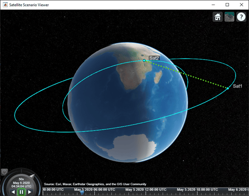
Visualize the line of sight between the satellites.
play(sc);
Set up the satellite scenario.
startTime = datetime(2021,8,5);
stopTime = startTime + days(1);
sampleTime = 60;                                      % seconds
sc = satelliteScenario(startTime,stopTime,sampleTime);
Add satellites to the scenario from a SEM almanac file.
sat = satellite(sc,"gpsAlmanac.txt","OrbitPropagator","gps");
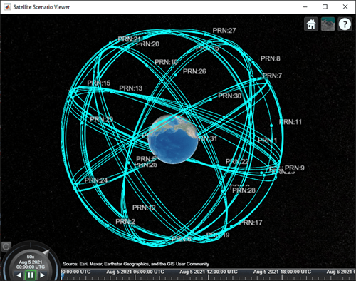
Visualize the GPS constellation.
v = satelliteScenarioViewer(sc);
References
[1] Hoots, Felix R., and Ronald L. Roehrich. Models for propagation of NORAD element sets. Aerospace Defense Command Peterson AFB CO Office of Astrodynamics, 1980.
[2] Vallado, David, et al. “Revisiting Spacetrack Report #3.” AIAA/AAS Astrodynamics Specialist Conference and Exhibit, American Institute of Aeronautics and Astronautics, 2006, https://doi.org/10.2514/6.2006-6753
Version History
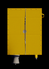
Introduced in R2021aStarting R2024a, use the Visual3DModel (Aerospace Toolbox) property of Satellite to display a small satellite in satelliteScenarioViewer (Aerospace Toolbox) using the new SmallSat.glb model.
SmallSat |
| SmallSat.glb |
See Also
Objects
satelliteScenario|GroundStation|Access|satelliteScenarioViewer|Eclipse(Aerospace Toolbox) |Platform

