Process Point Clouds
A point cloud is a set of data points in 3-D space. The points together represent a 3-D shape or object. Each point in the data set is represented by an x, y, and z geometric coordinate. Point clouds provide a means of assembling a large number of single spatial measurements into a dataset that can be represented as a describable object. Point cloud processing is used in robot navigation and perception, depth estimation, stereo vision, visual registration, and in advanced driver assistance systems (ADAS). Computer Vision Toolbox™ algorithms provide point cloud processing functionality for downsampling, denoising, and transforming point clouds. The toolbox also provides point cloud registration, geometrical shape fitting to 3-D point clouds, and the ability to read, write, store, display, and compare point clouds. You can combine multiple point clouds to reconstruct a 3-D scene, or build a map with registered point clouds, detect loop closures, optimize the map to correct for drift, and perform localization in the prebuilt map. For more details, see Implement Point Cloud SLAM in MATLAB.
To perform point cloud registration, the process of aligning two or more point clouds to a single coordinate system, you typically start with one point cloud as the reference, or fixed point cloud, and then align other, or moving, point clouds to it. The absolute pose of a point cloud refers to its global position and orientation with respect to a reference frame, often known as the world coordinate frame. Computer Vision Toolbox provides various registration techniques to register a moving point cloud to a fixed point cloud. These techniques include iterative closest point (ICP), normal distributions transform (NDT), phase correlation, and coherent point drift (CPD). You can also use the Lidar Registration Analyzer (Lidar Toolbox) app to interactively register and compare the results of using different registration techniques, tuning parameters, and preprocessing steps.
Functions
Blocks
Topics
- Choose a Point Cloud Viewer
Compare visualization functions.
- Choose SLAM Workflow Based on Sensor Data
Choose the right simultaneous localization and mapping (SLAM) workflow and find topics, examples, and supported features.
- Implement Point Cloud SLAM in MATLAB
Understand point cloud registration and mapping workflow.
- Getting Started with Point Clouds Using Deep Learning
Understand how to use point clouds for deep learning.
- The PLY Format
The Stanford Triangle Format.
- Getting Started with Point Clouds Using Deep Learning
Understand how to use point clouds for deep learning.
- Choose Function to Visualize Detected Objects
Compare visualization functions.
- Labeling, Segmentation, and Detection (Lidar Toolbox)
Label, segment, detect, and classify objects in point cloud data using deep learning and geometric algorithms
Featured Examples

Build a Map from Lidar Data Using SLAM
Process lidar data to build a map and estimate a vehicle trajectory using simultaneous localization and mapping.

Build a Map from Lidar Data Using SLAM on GPU
Perform 3-D simultaneous localization and mapping (SLAM) on an NVIDIA® GPU.

Build a Map from Lidar Data
Process 3-D lidar sensor data to progressively build a map, with assistance from inertial measurement unit (IMU) readings.
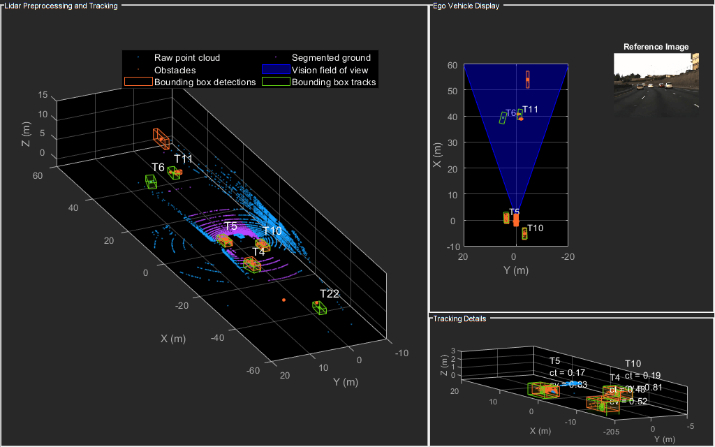
Detect and Track Vehicles Using Lidar Data
Track vehicles using measurements from a lidar sensor mounted on top of an ego vehicle.

Train Classification Network to Classify Object in 3-D Point Cloud
Train a classification network to classify objects in a 3-D point cloud.

3-D Point Cloud Registration and Stitching
Combine multiple point clouds to reconstruct a 3-D scene using Iterative Closest Point (ICP) algorithm. It then shows how to leverage color information available in the point clouds to improve the accuracy of the scene.

Design Lidar SLAM Algorithm Using Unreal Engine Simulation Environment
Record synthetic sensor data from a 3-D simulation environment, and develop a simultaneous localization and mapping (SLAM) algorithm using the recorded data.

Ground Plane and Obstacle Detection Using Lidar
Process 3-D lidar data from a sensor mounted on a vehicle by segmenting the ground plane and finding nearby obstacles.