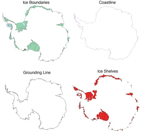
Antarctic boundaries, grounding line, and masks from InSAR
A complete MEaSUREs grounding line, coast line, and mask dataset from Mouginot et al.

You are now following this Submission
- You will see updates in your followed content feed
- You may receive emails, depending on your communication preferences
Cite As
Greene, Chad A., et al. “Antarctic Mapping Tools for Matlab.” Computers & Geosciences, vol. 104, Elsevier BV, July 2017, pp. 151–57, doi:10.1016/j.cageo.2016.08.003.
Mouginot, Jeremie, and University Of California Irvine. MEaSURES Antarctic Boundaries for IPY 2007-2009 from Satellite Radar, Version 2. NASA National Snow and Ice Data Center DAAC, 2017, doi:10.5067/AXE4121732AD.
Acknowledgements
Inspired by: Bedmap2 Toolbox for Matlab, MODIS Mosaic of Antarctica, MEaSUREs, Antarctic Mapping Tools, Antarctic Drainage Basins, ASAID grounding lines
Inspired: Antarctic Gravimetric Mass Balance (Groh & Horwath)
General Information
- Version 3.0.3 (7.39 MB)
-
 View License on GitHub
MATLAB Release Compatibility
- Compatible with any release
Platform Compatibility
- Windows
- macOS
- Linux
| Version | Published | Release Notes | Action |
|---|---|---|---|
| 3.0.3 | port to github |
||
| 3.0.2 | Updated Live Scripts |
||
| 3.0.1 | Added live scripts |
||
| 3.0.0 | Now includes basin_data, plot_basin, and inbasin functions. Also, the isiceshelf function now lets you specify a single ice shelf of interest. |
||
| 2.0.0 | Updated for the version 2 data release. |
||
| 1.1.0 | Fixed a 1 km vertical (y) offset in mask georeference. |
||
| 1.0.0 |

