egoPointCloudExtractor
Description
Add-On Required: This feature requires the Scenario Builder for Automated Driving Toolbox add-on.
The egoPointCloudExtractor object extracts local point clouds
from a larger point cloud with reference to an ego trajectory. The object crops the input
point cloud for a specified region around each waypoint in the specified input trajectory and
transforms the cropped point clouds to the vehicle coordinate system by emulating a lidar
sensor mounted on an ego vehicle. For more information on the vehicle coordinate system, see
Vehicle Coordinate System.
Creation
Syntax
Description
pcExtractor = egoPointCloudExtractor(ptCloud,trajectory)egoPointCloudExtractor object pcExtractor with the
PointCloud and Trajectory properties set by
the ptCloud and trajectory arguments,
respectively.
pcExtractor = egoPointCloudExtractor(ptCloud,trajectory,params)SensorParameters property using the
params argument. If you use the extractFrame
object function on an egoPointCloudExtractor object created using this
syntax, the function returns organized point clouds. For more information, see What Are Organized and Unorganized Point Clouds? (Lidar Toolbox).
pcExtractor = egoPointCloudExtractor(___,Name=Value)MaxRange=80 specifies the maximum detection range, from the ego
vehicle, at which to extract a point cloud as 80 meters.
Note: This feature also requires the Lidar Toolbox™.
Input Arguments
Name-Value Arguments
Properties
Object Functions
extractFrame | Extract point cloud frame |
hasFrame | Check if point cloud frame is available to read |
reset | Reset ego point cloud extractor object to initial state |
Examples
Load recorded point cloud data into the workspace.
ptCloud = pcread("USGS_LPC_CA_NoCAL_3DEP_Supp_Funding_2018_D18_w2276n1958_Cropped_geoReferenced.pcd");Display the point cloud object.
pcshow(ptCloud)
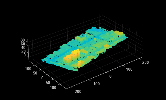
Specify the xyz-coordinates of waypoints to create a trajectory. The trajectory coordinates must be within the spatial range of the loaded point cloud data.
egoTraj = [-122.8437 12.1113 39.8113;
            -21.3297 32.1351 33.9599;
             80.4809 49.1138 32.9193];
Specify timestamps for the waypoints of the trajectory.
timestamps = (1:3)';
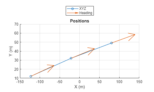
Create a trajectory object by using the specified xyz-coordinates and timestamps.
traj = recordedSensorData("trajectory",timestamps,egoTraj);Plot the trajectory object.
plot(traj,HeadingStep=1,ShowHeading=true)
Create an ego point cloud extractor object using the point cloud and trajectory information.
pcExtractor = egoPointCloudExtractor(ptCloud,traj)
pcExtractor =
  egoPointCloudExtractor with properties:

              Height: 1.6000
            MaxRange: 120
    SensorParameters: []
          PointCloud: [1×1 pointCloud]
          Trajectory: [1×1 scenariobuilder.Trajectory]
      NumPointClouds: 3
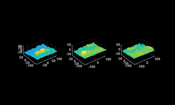
Extract and display point cloud frames from the ego point cloud extractor object until it has no new frames to extract.
figure
frame = 0;
while(hasFrame(pcExtractor))
    pcFrame = extractFrame(pcExtractor);
    frame = frame + 1;
    subplot(1,3,frame)
    pcshow(pcFrame)
end
Reset the ego point cloud extractor object.
reset(pcExtractor)
Load recorded point cloud data into the workspace.
ptCloud = pcread("USGS_LPC_CA_NoCAL_3DEP_Supp_Funding_2018_D18_w2276n1958_Cropped_geoReferenced.pcd");Specify the xyz-coordinates of waypoints to create a trajectory. The trajectory coordinates must be within the spatial range of the loaded point cloud data.
egoTraj = [-122.8437 12.1113 39.8113; ...
            -21.3297 32.1351 33.9599; ...
             80.4809 49.1138 32.9193];
Specify timestamps for the waypoints of the trajectory.
timestamps = (1:3)';
Create a trajectory object using the specified xyz-coordinates and timestamps.
traj = recordedSensorData("trajectory",timestamps,egoTraj);Specify lidar sensor parameters.
params = lidarParameters("HDL64E",1024)params =
lidarParameters with properties:
HorizontalResolution: 1024
VerticalResolution: 64
VerticalFoV: [2.8100 -23.9500]
VerticalBeamAngles: [2.8100 2.5100 2.1900 1.8600 1.5200 1.1500 0.8900 0.4800 0.2300 -0.1500 -0.5200 -0.8800 -1.1800 -1.5500 -1.8400 -2.2200 -2.5300 -2.9100 -3.2000 -3.5800 -3.8400 -4.2600 -4.5700 -4.9600 -5.2900 -5.6100 -5.8900 … ] (1×64 double)
HorizontalFoV: 360
HorizontalAngResolution: 0.3516
HorizontalBeamAngles: [0 0.3516 0.7031 1.0547 1.4062 1.7578 2.1094 2.4609 2.8125 3.1641 3.5156 3.8672 4.2188 4.5703 4.9219 5.2734 5.6250 5.9766 6.3281 6.6797 7.0312 7.3828 7.7344 8.0859 8.4375 8.7891 9.1406 9.4922 9.8438 … ] (1×1024 double)
SweepStartAngle: 90
RotateClockwise: 1
Create an ego point cloud extractor object using the point cloud, ego trajectory, and lidar sensor parameter information.
pcExtractor = egoPointCloudExtractor(ptCloud,traj,params)
pcExtractor =
  egoPointCloudExtractor with properties:

              Height: 1.6000
            MaxRange: 120
    SensorParameters: [1×1 lidarParameters]
          PointCloud: [1×1 pointCloud]
          Trajectory: [1×1 scenariobuilder.Trajectory]
      NumPointClouds: 3
Extract and visualize all point cloud frames from the ego point cloud extractor object.
while(hasFrame(pcExtractor))
    pcFrame = extractFrame(pcExtractor);
    pcshow(pcFrame)
end

Algorithms
For each waypoint specified in the input trajectory trajectory, the
object extracts a point cloud frame based on these conditions:
Waypoints in the specified input trajectory
trajectorymust be located within the spatial range of the input point cloudptCloud.The input point cloud
ptCloudmust contain lidar points around a specified waypoint within the range defined by theMaxRangeandHeightproperties.
Version History
Introduced in R2025a